Tag Archives: public transit

BAM: San Jose to Santa Rosa, and beyond!

As part of my ongoing fantasy reworking of Bay Area transit, here is the next installment: a 150+ mile rail corridor from Cloverdale to Gilroy, including San Jose, San Francisco, Santa Rosa and more. It sounds crazy I know, but hear me out.

First of all, remember that my transit plans are only loosely tied to reality. I have created a world where the vast majority of public transit is handled by one agency: the imaginary Bay Area Metro, or BAM. In this world there are no environmental impact surveys, no budget deficits, no earthquakes and no NIMBYism. I just want to imagine what Bay Area transit could be if our leaders were more visionary, our state was less broke, and our populace was less obstructionist.

Much of the infrastructure for the Cloverdale -> Gilroy train already exists. It includes the entire length of the work-in-progress SMART system (Cloverdale -> Larkspur), approved by voters in 2008. That right there is 70 miles of track.

Additionally the 60 miles of Caltrain’s existing tracks between Millbrae and Gilroy is part of the corridor.

Finally, the 10 miles of BART track between Millbrae and Daly City is the last bit of existing infrastructure to be included.

That leaves roughly 20 miles of track to lay, and eight or so stations to construct. Not a trivial task to be sure, but far easier to get your head around than an entire 150+ mile system.

At this point I should probably explain the monstrous caveat with the above plan. You see, even though in my world Caltrain and BART (and all the other transit agencies) have merged, the physical reality is that Caltrain and BART use different gauge tracks in their systems. Caltrain uses what’s called standard gauge, where the distance between rails is 4 feet, 8.5 inches, while BART uses Indian gauge at 5 feet, 6 inches. So clearly my idea as described would appear to be fatally flawed.

The solution of course is to rip up the BART tracks (yes all 100+ miles of them!) and replace them with standard gauge, which is how it should have been built all along. Standard gauge is used by 60% of railroads worldwide, including the New York Subway and Chicago’s ‘L’ train. Once the BART tracks are replaced, we can have true integration between it and Caltrain (and eventually Amtrak’s Capitol Corridor to Sacramento, and the Altamont Commuter Express to Stockton).

Caveat aside there is still the expensive and politically difficult task of building the 20 miles of track between the southern terminus of the SMART line (Larkspur Landing) and the Daly City station. Below you’ll see my proposal for such a system. The way I see it, most or all of the new track running through San Francisco would be underground, while the part in Marin would be mostly above-ground.

And yes, it goes across the Golden Gate Bridge! How cool would that be to remove a couple lanes of traffic to accommodate a train? People would go ape-shit in protesting this of course, but I don’t care. Marin commuters can take the train to work. Commuting to downtown SF will be a snap because if you remember from my previous post, the BAM system also has a new subway running the entire length of Geary street. These two lines will intersect at a new subway station at the intersection of Geary and Park Presidio Blvd, allowing for easy access to downtown.

So I guess that’s enough backstory. Below are a few maps showing the proposed layout.

The colors are as follows: red is the existing commuter rail infrastructure (BART and Caltrain), green is future commuter rail growth (both real and imaginary), blue is existing light rail (MUNI), and cyan is future light rail growth. Purple icons represent transfer stations.

The first map shows the entire system. You can zoom and scroll around the map as with any Google map, or look below at some pre-zoomed views.


View SMART Extension in a larger map

The second map is a closeup of the new rail that would be laid along 19th Avenue/Park Presidio Boulevard in San Francisco up to the Golden Gate Bridge. Note the station placement intersects with existing light rail lines at Judah and Taraval, and the future rail line at Geary. It also has strategic station placement at SFSU/Stonestown, the museum complex at Golden Gate Park, and the Golden Gate Bridge itself.


View SMART Extension in a larger map

This final map shows southern Marin. The tracks would be primarily above ground, with two new stations south of the already planned Larkspur Landing Station. I envision a large park-and-ride at the Strawberry Station to accommodate SF commuters. And yes, I know it’s pretty ambitious to include a station at Sausalito, but what the hell.


View SMART Extension in a larger map

Transit

As I mentioned in a previous post, I consider myself somewhat of a public transit nerd. I love public transit. Specifically I love train-based transit; buses can go to hell.

Growing up on the fringes of Tucson, with a single Mom, and no older siblings to shuttle me around, I was often left to the mercy of the Sun Tran bus system. Now, in all fairness, Sun Tran was not a terrible system. It covered the city thoroughly, and the buses were modern, air-condidtioned and comfortable.

But Sun Tran had one major flaw: it operated buses, and not trains.

It’s an interesting question why I, and so many people, prefer trains to buses. Don’t get me wrong; I’m not completely above riding buses, but I feel more like I suffer through them, than enjoy them. In part, I think there is a certain classism amongst myself and my peer group — you know the type; we’re perfectly happy to take BART to San Francisco for our commute, or a night out (nevermind the godawful closing time of 12:00), but god forbid we ride the 72 down San Pablo through West Oakland.

Another anti-bus argument, and perhaps a more reasonable one, is that they are stuck on city streets, at the whims of traffic, and so are slower and less reliable than a train system.

Plus people romanticize trains. Whether you’re a subway-riding New York commuter, a five-year old fan of Thomas the Tank Engine, a model-train hobbyist, or a backpacking 20-something with a Eurail pass, trains are just cool. Buses? Well, not so much…

Bay Area transit is decent, especially for a West Coast city, but it could be SO much better. Maybe the BART system was a bold idea in its day, but since then little has changed. It’s true that BART now goes to SFO, and further out into the East Bay exurbs, but that’s hardly bold. What about the densely populated, inner bay area? Arguably, investing in more BART coverage in San Francisco and Oakland would server more people than extending the fringes (which by the way just encourages more leapfrog sprawl instead of denser urban areas).

But it’s not just BART that we need to consider, and that gets to the crux of one of the biggest problems we have: too many transit agencies. The Bay Area’s 7.5 million residents are served by many different agencies. Here’s just a handful off the top of my head:  SF MuniBART,CaltrainAC TransitSamTransGolden Gate Transit.

Now I understand the reasons for this: primarily that the Bay Area is made up of a diverse group of cities and counties, each with its own interests, demographics, taxes and budgets, and their transit systems have grown up organically, more-or-less independent of one another. It would be impossible to have a regional transit system with all those competing interests. Right?

Wrong!

New York’s MTA serves many  millions of people in 14 counties in two states, including subways, commuter rail, and yes, buses. Portland’s TriMet covers three counties, and is widely considered a model for smart, sustainible approach to transit, and urban planning in general. Elsewhere in California, yes it is true that the Metro agency is limited to Los Angeles County, but that includes more people than the Bay Area, and in many diverse municipalities, over a similarly large geographical area.

So why is a regional approach better?

For starters, with a regional authority you have planners looking at the big picture, so they can work to accommodate transit patterns that cross city and county lines. Also, with regional control you could greatly eliminate redundant transit service and administrative overhead, and simplify union wage/benefits negotiations.

A third reason is the greater customer simplicity of one single system, with one single fee structure and transfer policy. Wouldn’t it be great, for example, if you could exit BART at Civic Center, and go directly to the N-Judah Muni line, without having to climb to the ticket level, exit BART, then enter Muni, and go back down to your new train?

Besides the difficulty of wrangling and combining the multitude of transit agencies, there are certainly other major issues with expanding Bay Area transit. They include paying for it (California is broke), geology (ack, earthquakes!), geography (there are bodies of water and mountains in the way), and NIMBYism (yes to transit, but not in my neighborhood!).

Those things don’t concern me. In my Sim-City-esque mindset, I am King Dan, and I make the transit decisions. Pay for it? Bah, toll roads and gas taxes. Earthquakes? They do it in Japan! Cross the bay? Build more bridges! NIMBYism? Tough shit, I make the decisions.

And so, to that end, I present to you, the re-imagining of the Bay Area’s transit network in my vision. Naturally, caveats abound. For one thing, I am only going to concern myself with trains: commuter, subway, and light rail. Buses (and ferries) are obviously important components to the system, but since this is my transit-fantasy, I’m going to pretty-much ignore them, except of course where bus lines will likely be replaced by rail.

I have purposely left out a couple of rail lines into San Jose: Amtrak’s Capitol Corridor, and the Altamont Commuter Express. Also missing is Santa Clara county’s VTA light rail system. Maybe eventually I’ll focus more on the South Bay, but right now it will be mostly SF and Oakland.

Also ignored is the planned California high-speed rail. It’s a costly endeavor, with a lot of problems to solve, and a long ways away. Someday I might broaden my scope to the whole state, but for the moment I’m focusing on the Bay Area.

This is going to be an ongoing series of posts, as I plan and refine my transit takeover. I’ll add and modify lines to the system, and provide maps to show off the ideas.

For starters let’s take a look at how the Bay Area’s transit looks currently. Below is a map showing the three major rail systems. Red lines are BART (primarily commuter rail, with some subway stations in downtown San Francisco, Berkeley and Oakland), aqua is Caltrain (commuter rail), and blue is SFMuni (light rail streetcars). The markers indicate subway and above ground stations on their respective lines. The purple markers are dual-purpose stations, for example the Market Street subway stations serve both BART and Muni. Looking at this view, it looks like we have pretty good coverage! San Francisco, for those geographically challenged, is the top of the western peninsula on the map. You can see it contains a rather dense-looking array of transit options.

View Bay Area Transit Today in a larger map

But looks can be deceiving. Here is a zoomed-in look at San Francisco. Notice how, despite the seeming-density in the view above, it’s a bit disappointing close-up. Not only is the northwestern quadrant completely devoid of trains, but also huge swaths of the rest of the city are not covered. Even the densely populated northeast corner is only serviced by the Market street subway, and the historic streetcar, which runs from Market up the waterfront to Fisherman’s Wharf. The old-fashioned streetcars are charming, but they are slow, and serve tourists more than locals. And the light rail lines in the western half of the city, once they’ve exited the subway, are pretty slow themselves. They run on surface streets, so have similar traffic problems as buses.

View Bay Area Transit Today in a larger map

Now remember, in the new Last-Dan-Standing-Bay-Area utopia, there is no MUNI, no Caltrain, etc. All Bay Area transit is consolidated into one agency: let’s call it Bay Area Metro, or BAM. BAM operates commuter rail (i.e. Caltrain and BART) and light rail (i.e. MUNI), plus all the rest of the agencies I list above (and more).

So first, what does the current system look like under BAM. I’ll change the colors to define the type of rail line, red for commuter, and blue for light rail. Also, let’s add in any known, or proposed changes to the Bay Area systems that are in the pipeline* such as the Transbay Terminal, the exciting, but flawed, central subway, BART’s extensions to Livermore and Santa Clara, and the SMART rail system that will connect Sonoma county with Marin. I’ll color those too: green for commuter rail, and aqua for light rail.

View MBA in a larger map

Finally, below I will add the first fantasy subway line across San Francisco: the six mile Geary line. Remember, the green indicates a new BART type of commuter rail, so I envision this new Geary line meeting up with the current BART subway at Montgomery and continuing into the East Bay. At least for now. Future posts may alter my crazy scheme even more. Mwahahahahahahaha!

View Geary in a larger map

* I am purposely ignoring the Oakland Airport Connector, as I have a better plan for getting to and from the airport. Stay tuned for a future post that explains it!

Secret Adventure Day #8

Your mission, should you choose to accept…

BJ and I began our awesome “Secret Adventure Day” tradition just over two years ago. We take turns, surprising each other with an entire day’s, or sometimes weekend’s, activities, averaging one adventure about every three months.

Last Saturday was our eighth such event and it was my turn to be surprised. My instructions were as follows, given to me one day ahead:

Tomorrow, please dress in a sophisticated manner, probably with layers because you’ll be in temperatures from 50 degrees to 70 degrees. Also, please wear shoes that are comfortable for walking. There is a 33% chance of rain, so don’t wear things that can’t get wet and consider bringing a rain jacket and/or an umbrella (more sophisticated).

Please pack whatever you need to stay overnight somewhere. Our Sunday activities are minimal so you don’t need to wear any certain clothes on Sunday, in fact, if you wanted to you could re-wear Saturday’s clothes.

Tomorrow will be a long day (do we ever make secret adventure days not long?), so tonight let’s make sure to get good sleep. We’ll be leaving the house at 8:30 or 8:35. I would recommend drinking coffee & having a small snack (small bowl of cereal maybe?) before leaving the house.

Make sure your phone is charged. Feel free to bring your little camera, but don’t bring your big camera.

Gettin’ going

I followed the directions, dressing in sharp wool pants, a collared shirt, pea coat, and less-than-comfortable-but-oh-so-sophisticated boots. We left the house on-time, but as I started to walk towards the car I was quickly corrected. “We’re not taking the car” she said.

Smiling I turned around and she led me to the corner bus stop. We only waited a couple of minutes before old 18 lumbered up and we climbed aboard. From here I guessed that we would be hopping on BART in downtown Berkeley which is exactly what we did.

It’s actually a problem I have; I love being surprised, but on these adventures I cannot help but guess as to what is to come. Fortunately BJ still had plenty of surprises up her sleeve, which became clear as the day wore on.

We exited the subway at Civic Center. BJ got her bearings and led me a few blocks into the Tenderloin where there were innumerable unpleasantries to greet us. Sadly that is the price one must pay to reach our first destination: The Phoenix Hotel.

Part of the Joie de Vivre boutique hotel collection, the Phoenix is a diamond in the rough of the TL. It’s a modernized mid-century motel, with hip, tiki-themed decor. It was only 9:30 am, so we were just planning to drop our bags at the front desk, but it turned out that we could check-in early. Sweet!

We dropped the bags in the room, and I was warned that we would not be returning until late at night. I rifled through my bag, wondering if I needed anything, but no, I wanted to travel light. I hesitated, but even decided to leave my trusty LX3 camera, figuring my phone, and BJ’s point-and-shoot would be enough.

French soul food

Back outside we headed west to Polk street, and right around the corner was Brenda’s French Soul Food. Breakfast was at hand! Brenda’s is a hole-in-the-wall, New Orleans inspired, breakfast heaven. The meal consisted of eggs, biscuit, grits, beef grillades with a cajun gravy, a flight of four beignets (spicy crawfish, plain, apple, and chocolate) and chicory coffee. Holy shit it was good. And we had great service and a cozy atmosphere to boot. Brenda’s is aces in my book.
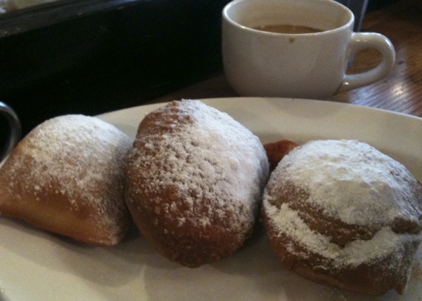
Brenda's beignets

Chicory coffee and beignets; tastes like New Orleans
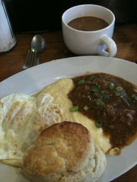
Brenda's stellar breakfast

Heaven on a plate

French fotos

Sufficiently stuffed, we strolled to the bus stop at Geary and Van Ness. The 38L came along pretty shortly, and we headed east. BJ had us exit at Market Street and guided me down to 3rd Street. Our destination was obvious: the Cartier-Bresson exhibit at SFMOMA

Paging through a book of French photographer Henri Cartier-Bresson’s stunning images, while working in a library in 1994, led me to pick up a camera myself. Photography became a minor obsession of mine and has helped shape my adult life, in school, travel, work, and more.

One of the countless of breathtaking images at the Cartier-Bresson exhibit.

One of the countless breathtaking images at the Cartier-Bresson exhibit.

So needless to say I was thrilled to be attending this exhibit. It is an insanely thorough retrospective, spanning everything from pre-Mao China to post-Hitler France, from sensual nudes, to cold celebrity portraiture. His street photography is breathtaking, and the in-camera framing is among the best. The show occupies one entire floor of the museum, and by the end of the circuit my dogs were certainly barking up a storm.

But there was more! We decided to explore a second photography exhibit, one-floor up. The show “Exposed” is a study of voyeurism, surveillance, and other uncomfortable flavors of photography. It is quite varied, and a little inconsistent, but full of compelling images nonetheless. There’s an uncomfortable feeling looking at many of the images, some with a peeping tom effect, and others depicting graphic violence. The show is not as worthy as Cartier-Bresson, but still interesting, especially for photo nerds like myself.

French lunch

Before we knew it, it was 2:00 and time for some lunch. Not that we were really very hungry after Brenda’s, but BJ had a reservation at nearby Cafe Claude and sitting down sounded like a grand idea.

Cafe Claude is a charming French bistro tucked in a hidden alleyway between the Financial District and Union Square. The food is authentically French, sophisticated, but not pretentious, and the service and environment are excellent.

To drink I enjoyed a ginger vodka martini, and BJ had the Liberte, made with rum and citrus, with a cinnamon/salt rim. Additional cocktails and/or wine was awfully tempting, but I knew we still had a long day ahead, and there would be more drinks to come, so somehow I resisted.

Meanwhile to eat we shared a splendid croque madame with green beans and endive salad, followed by chocolate mousse. I blame my mom for the mousse, as she got me hooked eating that stuff at an early age 🙂

Kitties

Post Claude, we ambled towards Union Square, dodging throngs of big-spending Christmas shoppers, aggressive cabbies, and Santa be-dressed youth. As we approached the seasonal skating rink I had a brief panic and guessed that we were going to do some ice skating. Fortunately BJ knows me better than that and we passed the rink, heading towards Macy’s.

Every Christmas Macy’s partners with the SPCA to create holiday window displays featuring puppies and kittens needing a home. It’s a great cause of course, and a pretty savvy marketing move as well, because it creates one more reason to make Macy’s a destination during the holiday shopping season.

The few kitties, and one puppy we saw were adorable, but sadly for us, about half of the animals were absent the windows as we went by. Happily though, according to the volunteer manning the donation box, the reason for at least one of the vacancies was a recent adoption, so we considered that a win.

Kabletown

The kitties at Macy’s turned out to be little more than a pitstop on the way to our next destination, which was a cable car ride. BJ said that either of the two Powell lines was a viable option, so we caught the less-popular Mason one without any delay.

Our destination turned out to be not far, at Washington Street. We got off and appropriately enough walked from the cable car, up a block to the…cable car museum! Now, you may not know this, but not only am I photo nerd, but a public transit and infrastructure nerd as well. I’m so nerdy in fact, that I often spend my free time redesigning the Bay Area transit systems in my own vision. For example, why oh why don’t we have a BART line running from Ocean Beach, all the way under Geary Street, to Montgomery? And what about Marin? BART to San Rafael? Come on people!!!

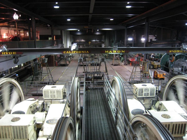
Sigh, I anticipate future blog posts about this, but to get back on track, let’s just say the museum was a superb choice on BJ’s part. It is full of all kinds of memorabilia to pore over, including a number of classic cars, signs, tokens, newspaper clippings, maps, and more. The 1906 earthquake is documented heavily as it greatly affected the system, and turned out to be the catalyst that sped the demise of the cable cars in favor of the automobile and electric streetcars. Best of all is the ability to view the power house, which is the beating heart of the cable car system. There are massive GE motors endlessly turning large grooved wheels, which guide the cables under the street.
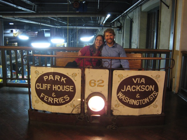
Next stop: adventure!
Next stop: adventure!

Cable car powerhouse

The cable car powerhouse. Look at those big motors!

Kabuki

From the museum we hiked to the top of Nob Hill to catch the 1 California bus. It was surprisingly crowded so we held on for dear life as the bus navigated the hills. Eventually we got a seat and people-watched until Fillmore, where we disembarked.

It was about 5:00, getting dark and raining a bit. But still, lots of folks were out and about, shopping, dining, etc. We passed them all, and before long found ourselves turning left at Geary where BJ guided me into the Kabuki Springs. We were right on time for a 60 minute massage appointment!

After being on my feet in stiff boots, and occasional pouring rain, the idea of lying down on a warm table for an hour, while a petite-yet-strong woman massaged away my kinks was divine. It was the perfect respite in the middle of our manic day, and we left the spa rejuvenated.

For our next activity, it was but a brief stroll around the corner to the Sundance Kabuki Cinemas for a screening of the new Harry Potter movie. We had recently caught up on the last few Potter DVD’s in anticipation of this new movie, so it was not entirely unexpected. Still, it was a perfect decision on BJ’s part, in terms of timing, and location. The Kabuki is an excellent upscale joint that allows reserved seating, has great picture and sound, and serves beer and wine. We had popcorn and drinks, and enjoyed the film quite a bit.

Kabaret Kab

After the movie we flagged down a cab. Little did I know that our driver was Buzz Brooks, mighty busking-cabbie extraordinaire. The ride was unimaginable. BJ announced our destination (the Wayfare Tavern), and as Buzz expertly navigated the heavy traffic of a Saturday night in SF, he started to warn us about some undesirable elements hanging out around the Wayfare after hours. One of them, he embarrassingly claimed, was actually his aunt Peg, and as he started to describe her, he leaned over, turned up the music, and broke out into song!

Buzz simultaneously was singing along with his own song which was playing on the stereo, while calmly maneuvering through the city streets. The music was smooth jazz, but the lyrics were Dr. Demento-esque insanity, describing an ugly, mustached, post-menopausal woman. He kept looking back at us, kind of freaking us out actually, as maybe his eyes weren’t quite on the road enough, but we arrived at the Wayfare unscathed.

I thought that somehow BJ had arranged the whole thing, but she assured me that no, it was just  incredibly serendipitous, and highly appropriate for Secret Adventure Day. I could see how easily it would have been to be annoyed by the whole thing, but fortunately we were in just the right mood, which allowed us to enjoy it. It was so much fun in fact, that I agreed to Buzz’s suggestion to pay $20, instead of the $8 on the meter, and he threw in a Kabaret Kab CD. I know, I’m a sucker.

Buzz is classic, kooky San Francisco. If you want a sense of what such a ride is like, here’s a YouTube video.

Wayfare

The Wayfare Tavern is a trendy new spot, and it was still going strong when we arrived at 10:00. BJ had tried weeks earlier to get us reservations, but to no avail — even at that late hour! We were relegated to the bar area, where we ordered cocktails and prowled for open seats. Soon enough, some people left and we snatched their seats. I knew right away that I would be ordering the burger, as I had read of its magical qualities already. BJ settled on a small dinner of mushroom soup paired with a bone marrow appetizer.
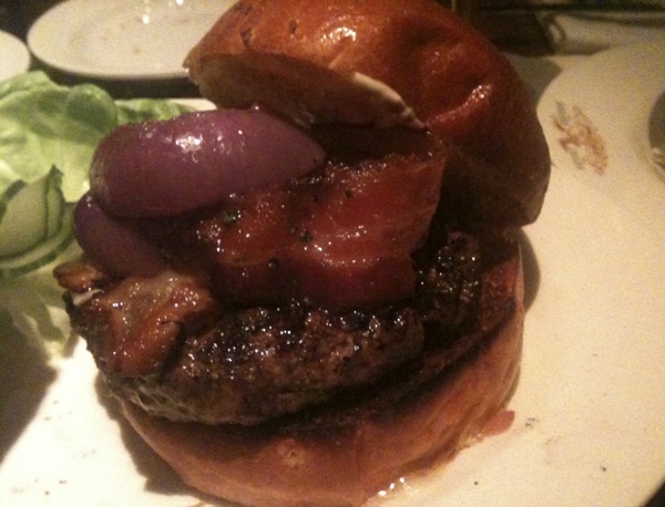
Wayfare burger

The Wayfare burger; does it live up to its $18 price tag?

Sadly the food was only just OK. We had heard a lot of buzz about the place, and frankly it didn’t live up. BJ’s soup was not well seasoned, and the burger was decent, but hardly worth $18. One highlight though was the oven-fresh popovers served in place of dinner rolls. Light, flaky, and buttery, these croissant-esque buns are pretty magical. And fortunately the cocktails and wine, friendly barstaff, and nice decor helped to make the visit worthwhile, but not spectacular.

Back to the ranch

We were done with our adventure. Full, tired, and a little drunk, we flagged down a cab for the journey back to the hotel. It was only 11:30, but after spending all day playing we were ready to turn in. Of course 11:30 on a Saturday night in the heart of the Tenderloin is not a sleep-friendly environment, and we struggled with the noisy neighborhood. There was the usual traffic and sirens, and a nearby house-party complete with drunken smokers talking loudly on the fire escape, and the surprise 3:30-am-wakeup-call of marathon sexual escapades from guests in the neighboring hotel room.

Still, we were able to sleep through most of it, and awoke to bagels and coffee poolside at the Phoenix. We sat under a heat lamp, watching rain drops dot the pool, and reminisced about the previous day’s adventures.

Thank you BJ for such a great Secret Adventure Day! I’ll have trouble topping that one 🙂